Navigation is easy these days, as we’ve entire complex computerized mapping systems and radio-based positioning systems to find ourselves anywhere on Earth. It might seem simple to use GPS these days, even trivial, but billions of dollars are what it took to make that happen.
Back in the day, navigation was simpler, and cheaper, using a handheld device and natural objects in space instead of artificial satellites with atomic clocks. Let’s learn about the sextant, and how it did its job.
Navigational Tool
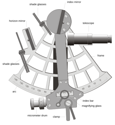
A sextant. Note the shades in front of the mirrors to avoid eye damage when viewing bright objects like the Sun, and the micrometer drum for fine adjustment—necessary for achieving high positional accuracy.
" data-large-file="https://hackaday.com/wp-content/uploads/2026/10/Marine_sextant.svg_.webp?w=500" src="https://hackaday.com/wp-content/uploads/2026/10/Marine_sextant.svg_.webp?w=366" alt="" width="366" height="400" srcset="https://hackaday.com/wp-content/uploads/2026/10/Marine_sextant.svg_.webp 500w,…